
Mapa topográfico Patcham
Mapa interactivo
Haga clic en el mapa para ver la altitud.
Acerca de este mapa
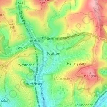
Nombre: Mapa topográfico Patcham, altitud, relieve.
Lugar: Patcham, Brighton and Hove, England, BN1 8QF, United Kingdom (50.84348 -0.16589 50.88348 -0.12589)
Altitud media: 98 m
Altitud mínima: 29 m
Altitud máxima: 189 m
Otros mapas topográficos
Haga clic en un mapa para ver su topografía, su altitud y su relieve.
Brighton
United Kingdom > England > Brighton and Hove
Brighton, Brighton and Hove, England, United Kingdom
Altitud media: 64 m
Carlton Hill
United Kingdom > England > Brighton and Hove > Brighton
Carlton Hill, Queen's Park, Brighton, Brighton and Hove, England, BN2 9HS, United Kingdom
Altitud media: 34 m
Hove
United Kingdom > England > Brighton and Hove
Hove, Brighton and Hove, England, BN3 2AD, United Kingdom
Altitud media: 35 m
Portslade by Sea
United Kingdom > England > Brighton and Hove
Portslade by Sea, Brighton and Hove, England, BN41 1GB, United Kingdom
Altitud media: 35 m
Rottingdean
United Kingdom > England > Brighton and Hove
Rottingdean, Brighton and Hove, England, United Kingdom
Altitud media: 56 m
Ovingdean
United Kingdom > England > Brighton and Hove
Ovingdean, Brighton and Hove, England, BN2 7BB, United Kingdom
Altitud media: 58 m
Stanmer Park
United Kingdom > England > Brighton and Hove > Stanmer
Stanmer Park, Coldean, Stanmer, Brighton and Hove, England, BN1 9QA, United Kingdom
Altitud media: 100 m
Stanmer
United Kingdom > England > Brighton and Hove
Stanmer, Brighton and Hove, England, BN1 9PZ, United Kingdom
Altitud media: 119 m