
Gracias por apoyar a este sitio ❤️
Haz una donación
Haz una donación
Mapa topográfico Laramie
Haga clic en el mapa para ver la altitud.
Gracias por apoyar a este sitio ❤️
Haz una donación
Haz una donación
Laramie
Laramie is on a high plain between two mountain ranges, the Snowy Range, about 30 miles (48 km) to the west, and the Laramie Range, 7 miles (11 km) to the east. The city's elevation above sea level is approximately 7,165 feet (2,184 m). The Laramie River runs through Laramie toward its confluence with the North Platte River east of the Laramie Range.
Gracias por apoyar a este sitio ❤️
Haz una donación
Haz una donación
Acerca de este mapa
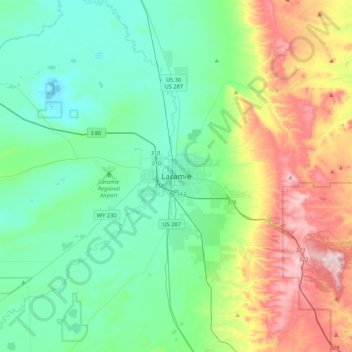
Nombre: Mapa topográfico Laramie, altitud, relieve.
Lugar: Laramie, Albany County, Wyoming, 82070, United States (41.15137 -105.75110 41.47137 -105.43110)
Altitud media: 2.299 m
Altitud mínima: 2.133 m
Altitud máxima: 2.744 m
Gracias por apoyar a este sitio ❤️
Haz una donación
Haz una donación