
Haz una donación
Mapa topográfico Glastonbury
Haga clic en el mapa para ver la altitud.
Haz una donación
Glastonbury
The town center experiences a humid continental climate (Dfa). However, the rural parts of the town, at an elevation of 800 feet near Bolton and Hebron, experience a colder climate which straddles the (Dfa) and (Dfb) lines.
Haz una donación
Acerca de este mapa
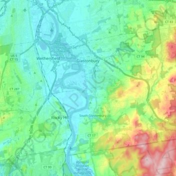
Nombre: Mapa topográfico Glastonbury, altitud, relieve.
Altitud media: 67 m
Altitud mínima: 0 m
Altitud máxima: 273 m
Haz una donación
Otros mapas topográficos
Haga clic en un mapa para ver su topografía, su altitud y su relieve.
Willington Hill
United States > Connecticut > Capitol Planning Region > Willington
Altitud media: 197 m
Haz una donación
Griswoldville
United States > Connecticut > Capitol Planning Region > Wethersfield
Altitud media: 34 m
Haz una donación
Talcott Mountain
United States > Connecticut > Capitol Planning Region > Bloomfield
Altitud media: 152 m
Haz una donación
South Wethersfield
United States > Connecticut > Capitol Planning Region > Wethersfield > Griswoldville
Altitud media: 22 m
Haz una donación
Talcott Mountain
United States > Connecticut > Capitol Planning Region > Bloomfield
Altitud media: 152 m
Haz una donación
Holcomb Farm
United States > Connecticut > Capitol Planning Region > Granby > West Granby
Altitud media: 116 m
Haz una donación
Johnson Hill
United States > Connecticut > Capitol Planning Region > West Hartford
Altitud media: 34 m
Stafford Springs
United States > Connecticut > Capitol Planning Region > Stafford
Altitud media: 200 m
Haz una donación
Barbara Drive
United States > Connecticut > Capitol Planning Region > Windsor Locks
Altitud media: 39 m
Haz una donación
Haz una donación