
Mapa topográfico Waynesboro
Mapa interactivo
Haga clic en el mapa para ver la altitud.
Acerca de este mapa
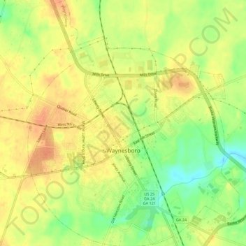
Nombre: Mapa topográfico Waynesboro, altitud, relieve.
Lugar: Waynesboro, Burke County, Georgia, United States (33.07199 -82.03730 33.11779 -81.98984)
Altitud media: 87 m
Altitud mínima: 60 m
Altitud máxima: 104 m
According to the United States Census Bureau, Waynesboro has a total area of 5.5 square miles (14.2 km2), of which 5.4 square miles (14.0 km2) is land and 0.039 square miles (0.1 km2), or 0.96%, is water. The city's elevation is 295 feet (90 m) above sea level. Pine, oak, dogwood, and other trees found in the South are in Waynesboro.
Otros mapas topográficos
Haga clic en un mapa para ver su topografía, su altitud y su relieve.
Watkins Pond
United States > Georgia > Burke County
Watkins Pond, Burke County, Georgia, United States
Altitud media: 78 m
Keysville
United States > Georgia > Burke County
Keysville, Burke County, Georgia, United States
Altitud media: 99 m