Mapa topográfico Yanam District
Mapa interactivo
Haga clic en el mapa para ver la altitud.
Acerca de este mapa
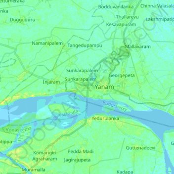
Nombre: Mapa topográfico Yanam District, altitud, relieve.
Lugar: Yanam District, Puducherry, 533464, India (16.70466 82.18613 16.76171 82.31371)
Altitud media: 5 m
Altitud mínima: -3 m
Altitud máxima: 16 m
Otros mapas topográficos
Haga clic en un mapa para ver su topografía, su altitud y su relieve.
Veerampattinam
India > Puducherry > Puducherry Taluk
Veerampattinam, Puducherry Taluk, Puducherry District, Puducherry, 605004, India
Altitud media: 3 m
Puducherry
India > Puducherry > Puducherry Taluk
Puducherry, Puducherry Taluk, Puducherry District, Puducherry, 605001, India
Altitud media: 10 m
Bahour Taluk
India > Puducherry > Bahour Taluk
Bahour Taluk, Puducherry district, Puducherry, India
Altitud media: 7 m
Karaikal
India > Puducherry > Karaikal Taluk
Karaikal, Karaikal Taluk, Karaikal district, Puducherry, 609602, India
Altitud media: 3 m
Oulgaret
India > Puducherry > Ozhukarai Taluk
Oulgaret, Ozhukarai Taluk, Puducherry District, Puducherry, 605005, India
Altitud media: 18 m
Ozhukarai Taluk
Ozhukarai Taluk, Puducherry district, Puducherry, India
Altitud media: 23 m
Nedungadu
India > Puducherry > Nedungadu
Nedungadu, Thirunallar Taluk, Karaikal, Puducherry, India
Altitud media: 5 m
Mahe
India > Puducherry > Mahe Taluk
Mahe, Mahe Taluk, Mahe district, Puducherry, 673310, India
Altitud media: 10 m
Yanam
India > Puducherry > Yanam Taluk
Yanam, Yanam Taluk, Yanam District, Puducherry, 533464, India
Altitud media: 5 m
Kalapet
India > Puducherry > Kalapet
Kalapet, Ozhukarai Taluk, Puducherry district, Puducherry, 605014, India
Altitud media: 14 m