
Mapa topográfico Grand View
Mapa interactivo
Haga clic en el mapa para ver la altitud.
Acerca de este mapa
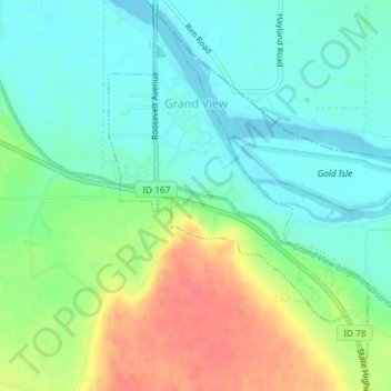
Nombre: Mapa topográfico Grand View, altitud, relieve.
Lugar: Grand View, Owyhee County, Idaho, United States (42.97062 -116.10170 42.99580 -116.07717)
Altitud media: 737 m
Altitud mínima: 716 m
Altitud máxima: 775 m
Grand View is located at 42°59′5″N 116°5′36″W / 42.98472°N 116.09333°W / 42.98472; -116.09333 (42.984803, -116.093277), at an elevation of 2,356 feet (718 m) above sea level. The city is on the Snake River, which is the border with Elmore County.
Otros mapas topográficos
Haga clic en un mapa para ver su topografía, su altitud y su relieve.
Homedale
United States > Idaho > Owyhee County
Homedale, Owyhee County, Idaho, 83628, United States
Altitud media: 683 m
Marsing
United States > Idaho > Owyhee County
Marsing, Owyhee County, Idaho, United States
Altitud media: 694 m
Sinker Butte
United States > Idaho > Owyhee County
Sinker Butte, Owyhee County, Idaho, United States
Altitud media: 892 m
Miller Water Table
United States > Idaho > Owyhee County
Miller Water Table, Owyhee County, Idaho, United States
Altitud media: 1.140 m