
Gracias por apoyar a este sitio ❤️
Haz una donación
Haz una donación
Mapa topográfico Bragg Creek
Haga clic en el mapa para ver la altitud.
Gracias por apoyar a este sitio ❤️
Haz una donación
Haz una donación
Acerca de este mapa
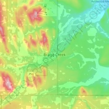
Nombre: Mapa topográfico Bragg Creek, altitud, relieve.
Lugar: Bragg Creek, Rocky View County, Alberta, T0L 0K0, Canada (50.91147 -114.60289 50.99147 -114.52289)
Altitud media: 1.332 m
Altitud mínima: 1.247 m
Altitud máxima: 1.494 m
Gracias por apoyar a este sitio ❤️
Haz una donación
Haz una donación
Otros mapas topográficos
Haga clic en un mapa para ver su topografía, su altitud y su relieve.
Gracias por apoyar a este sitio ❤️
Haz una donación
Haz una donación
Langdon
Canada > Alberta > Rocky View County
Langdon is located 12 km (7.5 mi) east of the City of Calgary at the intersection of Highway 560 (Glenmore Trail) and Highway 797, approximately 6 km (3.7 mi) south of the Trans Canada Highway and 7 km (4.3 mi) north of Highway 22X. It has an elevation of 1,005 m (3,297 ft).
Altitud media: 1.007 m