
Gracias por apoyar a este sitio ❤️
Haz una donación
Haz una donación
Mapa topográfico Manjoor
Haga clic en el mapa para ver la altitud.
Gracias por apoyar a este sitio ❤️
Haz una donación
Haz una donación
Acerca de este mapa
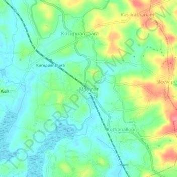
Nombre: Mapa topográfico Manjoor, altitud, relieve.
Lugar: Manjoor, Vaikom, Kottayam, Kerala, 686603, India (9.70870 76.49928 9.74870 76.53928)
Altitud media: 26 m
Altitud mínima: 0 m
Altitud máxima: 77 m
Gracias por apoyar a este sitio ❤️
Haz una donación
Haz una donación
Otros mapas topográficos
Haga clic en un mapa para ver su topografía, su altitud y su relieve.