
Haz una donación
Mapa topográfico Nob Hill
Haga clic en el mapa para ver la altitud.
Haz una donación
Acerca de este mapa
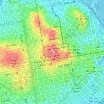
Nombre: Mapa topográfico Nob Hill, altitud, relieve.
Lugar: Nob Hill, San Francisco, California, 94109, United States (37.79321 -122.41530 37.79331 -122.41520)
Altitud media: 43 m
Altitud mínima: -1 m
Altitud máxima: 121 m
Haz una donación
Otros mapas topográficos
Haga clic en un mapa para ver su topografía, su altitud y su relieve.
Golden Gate Park
United States > California > San Francisco
In the 1860s, San Franciscans began to feel the need for a spacious public park similar to Central Park, which was then taking shape in New York City. Golden Gate Park was carved out of unpromising sand and shore dunes that were known as the Outside Lands, in an unincorporated area west of San Francisco's…
Altitud media: 71 m
Haz una donación
Haz una donación
San Francisco Maritime National Historical Park
United States > California > San Francisco
Altitud media: 11 m
Haz una donación
Haz una donación
Golden Gate Park
United States > California > San Francisco
Conceived ostensibly for recreation, the underlying purpose of the park was housing development and the westward expansion of the city. Field engineer William Hammond Hall prepared a survey and topographic map of the park site in 1870 and became its commissioner in 1871. He was later named California's first…
Altitud media: 71 m
Haz una donación
Haz una donación