
Mapa topográfico Schofield Barracks
Mapa interactivo
Haga clic en el mapa para ver la altitud.
Acerca de este mapa
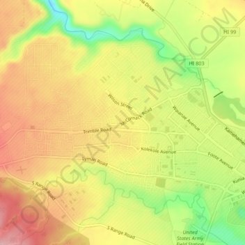
Nombre: Mapa topográfico Schofield Barracks, altitud, relieve.
Lugar: Schofield Barracks, Honolulu County, Hawaii, United States (21.47856 -158.08254 21.50819 -158.04103)
Altitud media: 279 m
Altitud mínima: 182 m
Altitud máxima: 353 m
Schofield Barracks has a tropical savanna climate. Owing to a higher elevation, Schofield is slightly cooler year round than Honolulu, but is still well within the realms of a tropical climate. Precipitation patterns closely resemble those of mediterranean climates being found in mainland California, but its warm winters prevents the climate from being classified as such.
Otros mapas topográficos
Haga clic en un mapa para ver su topografía, su altitud y su relieve.
Waipio Acres
United States > Hawaii > Honolulu County > Mililani
Waipio Acres, Mililani, Honolulu County, Hawaii, United States
Altitud media: 230 m
Mililani Mauka
United States > Hawaii > Honolulu County > Mililani
Mililani Mauka, Mililani, Honolulu County, Hawaii, United States
Altitud media: 254 m
Oʻahu Forest National Wildlife Refuge
United States > Hawaii > Honolulu County > Mililani
Oʻahu Forest National Wildlife Refuge, Mililani, Honolulu County, Hawaii, United States
Altitud media: 456 m