
Haz una donación
Mapa topográfico Friedenswald
Haga clic en el mapa para ver la altitud.
Haz una donación
Acerca de este mapa
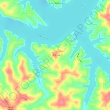
Nombre: Mapa topográfico Friedenswald, altitud, relieve.
Lugar: Friedenswald, Camden County, Missouri, 65052, United States (38.05389 -92.78263 38.09389 -92.74263)
Altitud media: 226 m
Altitud mínima: 196 m
Altitud máxima: 286 m
Haz una donación
Otros mapas topográficos
Haga clic en un mapa para ver su topografía, su altitud y su relieve.
Lake Of The Ozarks
United States > Missouri > Camden County > Osage Beach
The lake was created by the construction of the 2,543-foot (775 m) long Bagnell Dam by the Union Electric Company of St. Louis, Missouri. The principal engineering firm was Stone and Webster. Construction began August 8, 1929, and was completed in April 1931; the lake reached spillway elevation on May 20, 1931.
Altitud media: 265 m
Haz una donación
Linn Creek
United States > Missouri > Camden County
In 1929 it was announced that the Bagnell Dam would be constructed and the town would be flooded, causing controversy among the city's citizens. Almost all of the buildings were demolished, and the city was moved to a higher elevation, losing its designation as the county seat.
Altitud media: 250 m