
Mapa topográfico ZEC Bras-Coupé–Désert
Mapa interactivo
Haga clic en el mapa para ver la altitud.
Acerca de este mapa
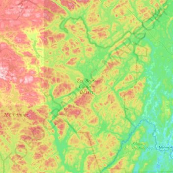
Nombre: Mapa topográfico ZEC Bras-Coupé–Désert, altitud, relieve.
Altitud media: 294 m
Altitud mínima: 161 m
Altitud máxima: 538 m
Otros mapas topográficos
Haga clic en un mapa para ver su topografía, su altitud y su relieve.
Lac Jean Pere
Canada > Quebec > Lac-Pythonga
Lac Jean Pere, Route 117, Lac-Pythonga, La Vallée-de-la-Gatineau, Outaouais, Quebec, Canada
Altitud media: 386 m
Lac Gippaw
Canada > Quebec > Lac-Pythonga
Lac Gippaw, Lac-Pythonga, La Vallée-de-la-Gatineau, Outaouais, Quebec, Canada
Altitud media: 306 m
Lac Érié
Canada > Quebec > Lac-Pythonga
Lac Érié, Lac-Pythonga, La Vallée-de-la-Gatineau, Outaouais, Quebec, Canada
Altitud media: 430 m
Réservoir Cabonga
Canada > Quebec > Lac-Pythonga
Réservoir Cabonga, La Verendrye 25, Lac-Pythonga, La Vallée-de-la-Gatineau, Outaouais, Quebec, Canada
Altitud media: 384 m
Rivière Gens de Terre
Canada > Quebec > Lac-Pythonga
Rivière Gens de Terre, Lac-Pythonga, La Vallée-de-la-Gatineau, Outaouais, Quebec, Canada
Altitud media: 371 m