
Gracias por apoyar a este sitio ❤️
Haz una donación
Haz una donación
Mapa topográfico Castle Crag
Haga clic en el mapa para ver la altitud.
Gracias por apoyar a este sitio ❤️
Haz una donación
Haz una donación
Castle Crag
The wooded height of Castle Crag rises between Broadslack Gill and the Derwent, the two streams meeting to the north beneath the outlying knoll of Low Hows. It has steep faces on all sides except the south, where a low ridge runs out and then swings west around the head of Broadslack Gill. A narrow col here provides the topographic link to High Spy.
Gracias por apoyar a este sitio ❤️
Haz una donación
Haz una donación
Acerca de este mapa
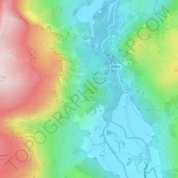
Nombre: Mapa topográfico Castle Crag, altitud, relieve.
Altitud media: 272 m
Altitud mínima: 78 m
Altitud máxima: 647 m
Gracias por apoyar a este sitio ❤️
Haz una donación
Haz una donación
Otros mapas topográficos
Haga clic en un mapa para ver su topografía, su altitud y su relieve.