
Mapa topográfico Tiverton
Mapa interactivo
Haga clic en el mapa para ver la altitud.
Acerca de este mapa
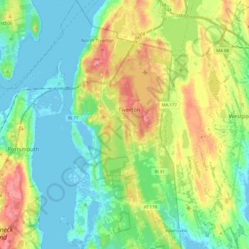
Nombre: Mapa topográfico Tiverton, altitud, relieve.
Lugar: Tiverton, Newport County, Rhode Island, 02878, United States (41.54544 -71.22130 41.67509 -71.12784)
Altitud media: 31 m
Altitud mínima: -5 m
Altitud máxima: 93 m
Much of the town is located along a granite ridge which runs in a north–south direction, rising approximately 170 feet in elevation from the bay. A large section of exposed granite can be observed at the highway cut for Route 24, near the Main Road interchange.
Otros mapas topográficos
Haga clic en un mapa para ver su topografía, su altitud y su relieve.
Portsmouth
United States > Rhode Island > Newport County
Portsmouth, Newport County, Rhode Island, United States
Altitud media: 19 m
Fort Wetherill
United States > Rhode Island > Newport County > Jamestown
Fort Wetherill, Highland Drive, Jamestown, Newport County, Rhode Island, 02835, United States
Altitud media: 4 m
Aquidneck Island
United States > Rhode Island > Newport County > Portsmouth
Aquidneck Island, Portsmouth, Newport County, Rhode Island, United States
Altitud media: 13 m
Newport
United States > Rhode Island > Newport County
Newport, Newport County, Rhode Island, 02840, United States
Altitud media: 8 m
Pocasset Hill
United States > Rhode Island > Newport County > Tiverton
Pocasset Hill, Tiverton, Newport County, Rhode Island, 02878, United States
Altitud media: 51 m
Jamestown
United States > Rhode Island > Newport County
Jamestown, Newport County, Rhode Island, 02835, United States
Altitud media: 8 m
Middletown
United States > Rhode Island > Newport County
Middletown, Newport County, Rhode Island, 02842, United States
Altitud media: 19 m
Little Compton
United States > Rhode Island > Newport County
Little Compton, Newport County, Rhode Island, United States
Altitud media: 9 m