
Gracias por apoyar a este sitio ❤️
Haz una donación
Haz una donación
Mapa topográfico South Sister
Haga clic en el mapa para ver la altitud.
Gracias por apoyar a este sitio ❤️
Haz una donación
Haz una donación
Acerca de este mapa
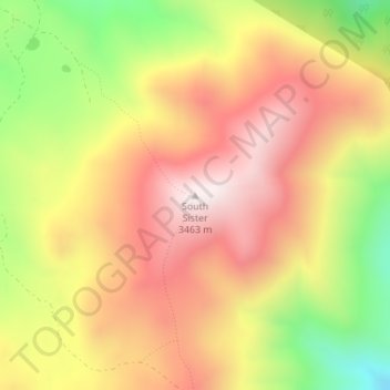
Nombre: Mapa topográfico South Sister, altitud, relieve.
Lugar: South Sister, Mono County, California, United States (38.48287 -119.30006 38.48297 -119.29996)
Altitud media: 3.109 m
Altitud mínima: 2.662 m
Altitud máxima: 3.449 m
Gracias por apoyar a este sitio ❤️
Haz una donación
Haz una donación
Otros mapas topográficos
Haga clic en un mapa para ver su topografía, su altitud y su relieve.
Mono Lake
United States > California > Mono County
Lake Russell was the prehistoric predecessor to Mono Lake, during the Pleistocene. Its shoreline reached the modern-day elevation of 7,480 feet (2,280 m), about 1,100 feet (330 m) higher than the present-day lake. As of 1.6 million years ago, Lake Russell discharged to the northeast, into the Walker River…
Altitud media: 2.008 m
Gracias por apoyar a este sitio ❤️
Haz una donación
Haz una donación
Gracias por apoyar a este sitio ❤️
Haz una donación
Haz una donación