
Mapa topográfico Sölden
Mapa interactivo
Haga clic en el mapa para ver la altitud.
Sölden
The main village of Sölden is at an elevation of 1,368 metres (4,488 ft) above sea level, and the upper village of Hochsölden at 2,090 m (6,857 ft) has 5 four-star hotels. The highest peak is the Wildspitze, at 3,768 m (12,362 ft), the second highest mountain in Austria, after the Großglockner.
Acerca de este mapa
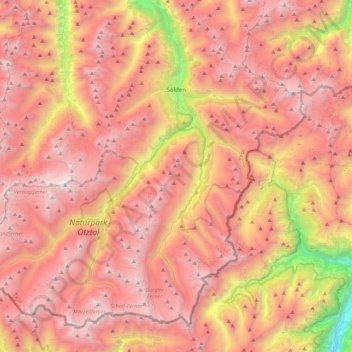
Nombre: Mapa topográfico Sölden, altitud, relieve.
Lugar: Sölden, Bezirk Imst, Tyrol, Austria (46.76285 10.72600 47.02239 11.16813)
Altitud media: 2.483 m
Altitud mínima: 499 m
Altitud máxima: 3.721 m
Otros mapas topográficos
Haga clic en un mapa para ver su topografía, su altitud y su relieve.
Oberlängenfeld
Austria > Tyrol > Bezirk Imst > Gemeinde Längenfeld > Längenfeld
Altitud media: 1.584 m
Unterlängenfeld
Austria > Tyrol > Bezirk Imst > Gemeinde Längenfeld > Längenfeld
Altitud media: 1.590 m