
Mapa topográfico Hameau des Pelletiers
Mapa interactivo
Haga clic en el mapa para ver la altitud.
Acerca de este mapa
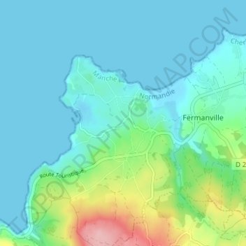
Nombre: Mapa topográfico Hameau des Pelletiers, altitud, relieve.
Altitud media: 26 m
Altitud mínima: -1 m
Altitud máxima: 134 m
Otros mapas topográficos
Haga clic en un mapa para ver su topografía, su altitud y su relieve.
Hameau du Cap Lévi
France > Normandie > Manche > Fermanville
Hameau du Cap Lévi, Fermanville, Cherbourg, Manche, Normandie, France métropolitaine, 50840, France
Altitud media: 15 m
Intheville
France > Normandie > Manche > Fermanville
Intheville, Fermanville, Cherbourg, Manche, Normandie, France métropolitaine, 50840, France
Altitud media: 28 m
Inglemare
France > Normandie > Manche > Fermanville
Inglemare, Fermanville, Cherbourg, Manche, Normandie, France métropolitaine, 50840, France
Altitud media: 21 m