
Mapa topográfico Peppermint Corner
Mapa interactivo
Haga clic en el mapa para ver la altitud.
Acerca de este mapa
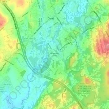
Nombre: Mapa topográfico Peppermint Corner, altitud, relieve.
Altitud media: 94 m
Altitud mínima: 62 m
Altitud máxima: 151 m
Otros mapas topográficos
Haga clic en un mapa para ver su topografía, su altitud y su relieve.
Collettes Grove
United States > New Hampshire > Rockingham County > Derry
Collettes Grove, Derry, Rockingham County, New Hampshire, 03841, United States
Altitud media: 79 m