
Mapa topográfico West Lafayette
Mapa interactivo
Haga clic en el mapa para ver la altitud.
Acerca de este mapa
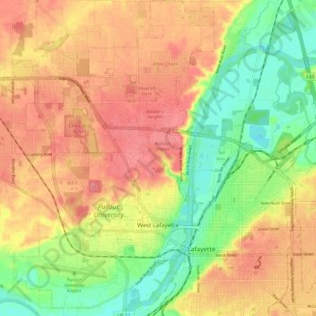
Nombre: Mapa topográfico West Lafayette, altitud, relieve.
Lugar: West Lafayette, Tippecanoe County, Indiana, United States (40.40002 -86.96244 40.48954 -86.88698)
Altitud media: 192 m
Altitud mínima: 150 m
Altitud máxima: 225 m
West Lafayette lies in central Tippecanoe County and overlooks the Wabash River, which borders the city on the east and south. Most of the city lies in eastern Wabash Township, though a small portion on the northeast side extends into Tippecanoe Township. Elevations range from slightly over 500 feet (150 m) near the river to more than 720 feet (220 m) in northern parts of the city near U.S. Route 52.
Otros mapas topográficos
Haga clic en un mapa para ver su topografía, su altitud y su relieve.
Happy Hollow Heights
United States > Indiana > Tippecanoe County > West Lafayette > Happy Hollow Heights
Happy Hollow Heights, West Lafayette, Tippecanoe County, Indiana, 46906, United States
Altitud media: 189 m
Buck Creek
United States > Indiana > Tippecanoe County
Buck Creek, Tippecanoe County, Indiana, 47924, United States
Altitud media: 202 m
Lafayette
United States > Indiana > Tippecanoe County > Lafayette
Lafayette, Tippecanoe County, Indiana, United States
Altitud media: 193 m