
Gracias por apoyar a este sitio ❤️
Haz una donación
Haz una donación
Mapa topográfico Burson
Haga clic en el mapa para ver la altitud.
Gracias por apoyar a este sitio ❤️
Haz una donación
Haz una donación
Acerca de este mapa
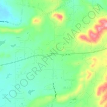
Nombre: Mapa topográfico Burson, altitud, relieve.
Lugar: Burson, Calaveras County, California, 95225, United States (38.16381 -120.91049 38.20381 -120.87049)
Altitud media: 135 m
Altitud mínima: 74 m
Altitud máxima: 255 m
Gracias por apoyar a este sitio ❤️
Haz una donación
Haz una donación
Otros mapas topográficos
Haga clic en un mapa para ver su topografía, su altitud y su relieve.
Rail Road Flat
United States > California > Calaveras County
This historic mining town, elevation 2,600 feet (788 m), was named after primitive mule-drawn ore cars used here. There was never actually a railroad here. The town was established in 1849. It was the site of an Indian council as well as the center of rich placer and quartz mining. Its largest producer was the…
Altitud media: 831 m
Gracias por apoyar a este sitio ❤️
Haz una donación
Haz una donación
Gracias por apoyar a este sitio ❤️
Haz una donación
Haz una donación