
Haz una donación
Mapa topográfico Canton
Haga clic en el mapa para ver la altitud.
Haz una donación
Acerca de este mapa
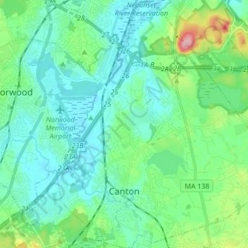
Nombre: Mapa topográfico Canton, altitud, relieve.
Lugar: Canton, Norfolk County, Massachusetts, 02021, United States (42.13770 -71.17804 42.22791 -71.06662)
Altitud media: 44 m
Altitud mínima: 8 m
Altitud máxima: 189 m
Haz una donación
Otros mapas topográficos
Haga clic en un mapa para ver su topografía, su altitud y su relieve.
Haz una donación
Haz una donación
Weymouth Woods
United States > Massachusetts > Norfolk County > Weymouth > South Weymouth > Pine Grove
Altitud media: 49 m
Haz una donación
Haz una donación
Lake Massapoag
United States > Massachusetts > Norfolk County > Sharon
Because of the lake and the fact that Sharon is at a slightly higher elevation than the surrounding towns, and because it is located on the main rail line going south from Boston, the shores of the lake developed into a minor summer resort with several large hotels, summer camps and cottage colonies. Temple…
Altitud media: 84 m
Haz una donación
Haz una donación
Haz una donación
Haz una donación
Haz una donación
Haz una donación
Wellesley Farms
United States > Massachusetts > Norfolk County > Wellesley > Wellesley Farms
Altitud media: 48 m
Haz una donación
Haz una donación