
Mapa topográfico Thrybergh
Haga clic en el mapa para ver la altitud.
Acerca de este mapa
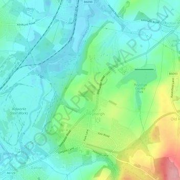
Nombre: Mapa topográfico Thrybergh, altitud, relieve.
Lugar: Thrybergh, Rotherham, South Yorkshire, England, United Kingdom (53.44022 -1.31933 53.47167 -1.27965)
Altitud media: 48 m
Altitud mínima: 16 m
Altitud máxima: 140 m
Otros mapas topográficos
Haga clic en un mapa para ver su topografía, su altitud y su relieve.
Treeton
United Kingdom > England > Rotherham
Catcliffe Flash, to the west of the village, is a local nature reserve that is made up of a lake and marshland formed as the elevation of the land beside the River Rother dropped due to coal mining subsidence. To the south-east of the village are three areas of ancient woodland, Treeton Wood, Hail Mary Hill…
Altitud media: 58 m
Kiveton Park
United Kingdom > England > Rotherham
Kiveton Park is located at approximately 53°20′30″N 1°15′30″W / 53.34167°N 1.25833°W / 53.34167; -1.25833, at an elevation of around 330 feet (100 m) above sea level, and is located 8 miles (13 km) west of Worksop, and 11 miles (18 km) south-east of both Sheffield, and Rotherham…
Altitud media: 104 m
Catcliffe
United Kingdom > England > Rotherham
The Catcliffe Glass Cone, part of the previous William Fenney's glassworks, is on Main Street. The centre of the village is dominated by a nine-arch viaduct that was built in 1901 to carry the Sheffield District Railway across the River Rother. Catcliffe Flash, to the south of the village, is a local nature…
Altitud media: 58 m
Sheffield and South Yokshire Navigation
United Kingdom > England > Rotherham > Thrybergh
Altitud media: 39 m