
Mapa topográfico Buntzen Lake
Mapa interactivo
Haga clic en el mapa para ver la altitud.
Acerca de este mapa
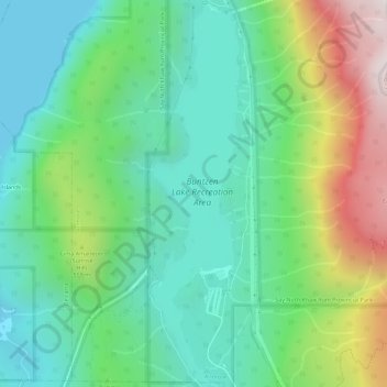
Nombre: Mapa topográfico Buntzen Lake, altitud, relieve.
Altitud media: 348 m
Altitud mínima: 0 m
Altitud máxima: 1.158 m
Hiking time: 6–8 hours return. Distance: 15 km (9 mi). Elevation gain: 1,020 m (3,350 ft). This is the most popular of the three Halvor Lunden trails. It passes thought ancient mountain forests and has a number of viewpoints from which overlook Vancouver. The trailhead is on Powerhouse Road, near the southeast corner of the South Beach parking area, and takes you up a steep climb of over 700m, passing the Polytrichum Lookout before reaching the "Lake district" which includes several small lakes and the larger Lindsay Lake.
Otros mapas topográficos
Haga clic en un mapa para ver su topografía, su altitud y su relieve.
Buntzen Bay
Canada > British Columbia > Metro Vancouver Regional District > Anmore
Buntzen Bay, Anmore, Metro Vancouver Regional District, British Columbia, Canada
Altitud media: 214 m
Burrard Inlet
Canada > British Columbia > Metro Vancouver Regional District > Anmore
Burrard Inlet, Anmore, District of North Vancouver, Metro Vancouver Regional District, British Columbia, Canada
Altitud media: 478 m