
Haz una donación
Mapa topográfico Surguja
Haga clic en el mapa para ver la altitud.
Haz una donación
Acerca de este mapa
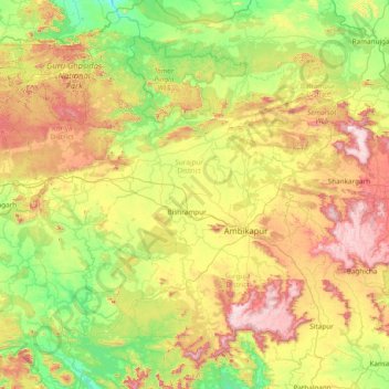
Nombre: Mapa topográfico Surguja, altitud, relieve.
Lugar: Surguja, Surajpur District, Chhattisgarh, India (22.55000 82.30000 23.95000 83.70000)
Altitud media: 574 m
Altitud mínima: 272 m
Altitud máxima: 1.227 m
Haz una donación
Otros mapas topográficos
Haga clic en un mapa para ver su topografía, su altitud y su relieve.
Koriya
Koriya District lies between 22°56′ and 23°48′ North and 81°56′ and 82°47′ East. It is bounded on the north-west by Manendragarh-Chirmiri-Bharatpur district, on the south by Korba District, on the east by Surajpur District. The area of the district is 5977 km2, of which 59.9% is forest area. The…
Altitud media: 609 m
Surguja
In Surguja bauxite deposits have been found in tertiary rocks. Due to decay and weathering of aluminium rich rocks, felspar usually kaolinised under tropical monsoon conditions, the weathering goes a step further and results in a residue rich in hydroxides of aluminium together with oxides of iron, manganese…
Altitud media: 619 m
Haz una donación
Haz una donación
Jashpur
Major rivers in the Mahanadi basin are Ib and its tributaries such as Dorki, Maini, Kokiya, Utai, Khadung, Girma and Burhi. In the eastern part, rivers named Baki and Lava Nadi flow in the Brahmani basin. Lower Ganges part is mainly drained by Geor and Kanhar rivers. The drainage pattern is dendritic and is…
Altitud media: 603 m
Sukma
This place can easily be a matter of research for the Archaeological department as there exists rare ancient sculptures in this area, one can see a sculpture on which Brahma,Vishnu and Mahesh the Trinity of Hindu faith can be seen on a single stone. Now with the elevation of this area into a new District…
Altitud media: 256 m
Haz una donación
Surajpur
Due to its mountainous topography, the district largely escaped the turmoil of the surrounding plains. The earliest inhabitants are said to be the Kols and Gonds, but there is evidence of more widespread civilization in the region. The rulers of Surguja State were Raksel Rajputs, and were said to have…
Altitud media: 572 m
Haz una donación
Haz una donación
Haz una donación
Haz una donación
Haz una donación
Haz una donación
Haz una donación
Haz una donación
Haz una donación
Raigarh
India > Chhattisgarh > Raigarh Tahsil
Raigarh is located at 21°54′N 83°24′E / 21.9°N 83.4°E / 21.9; 83.4. It has an average elevation of 215 metres (705 feet). The Kelo river flows through the city, which is one of its main water sources.
Altitud media: 216 m
Haz una donación
Haz una donación
Haz una donación
Sukma
This place can easily be a matter of research for the Archaeological department as there exists rare ancient sculptures in this area, one can see a sculpture on which Brahma, Vishnu and Mahesh the Trinity of Hindu faith can be seen on a single stone. Now with the elevation of this area into a new District…
Altitud media: 256 m
Haz una donación
Haz una donación
Haz una donación
Jashpur
Major rivers in the Mahanadi basin are Ib and its tributaries such as Dorki, Maini, Kokiya, Utai, Khadung, and Burhi. In the eastern part, rivers named Girma and Lava Nadi flow in the Brahmani basin. Lower Ganges part is mainly drained by Geor and Kanhar rivers. The drainage pattern is dendritic and is highly…
Altitud media: 603 m
Haz una donación