
Mapa topográfico Pasadena
Mapa interactivo
Haga clic en el mapa para ver la altitud.
Acerca de este mapa
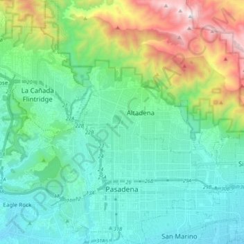
Nombre: Mapa topográfico Pasadena, altitud, relieve.
Altitud media: 549 m
Altitud mínima: 142 m
Altitud máxima: 1.852 m
An obscure portion of the Angeles Crest Highway (SR 2) in the San Gabriel Mountains cuts through Pasadena near the Angeles Crest Ranger Station. This 2-mile (3.2 km) stretch of highway in the Angeles National Forest is north of La Cañada Flintridge and west of Mount Wilson and is approximately 3,000 feet (910 m) in elevation.