
Gracias por apoyar a este sitio ❤️
Haz una donación
Haz una donación
Mapa topográfico Garstang
Haga clic en el mapa para ver la altitud.
Gracias por apoyar a este sitio ❤️
Haz una donación
Haz una donación
Acerca de este mapa
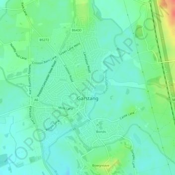
Nombre: Mapa topográfico Garstang, altitud, relieve.
Lugar: Garstang, Borough of Wyre, Lancashire, England, United Kingdom (53.89262 -2.79394 53.91382 -2.76443)
Altitud media: 24 m
Altitud mínima: 10 m
Altitud máxima: 59 m
Gracias por apoyar a este sitio ❤️
Haz una donación
Haz una donación
Otros mapas topográficos
Haga clic en un mapa para ver su topografía, su altitud y su relieve.