
Haz una donación
Mapa topográfico Caliente
Haga clic en el mapa para ver la altitud.
Haz una donación
Caliente
Caliente /kæliˈɛni/, /kæliˈɛnti/, formerly known as Culverwell and Calientes, is a city in Lincoln County, Nevada, United States. Its elevation is 4,300 feet (1,300 m). The population was 1,130 at the 2010 census, making it the least populated incorporated city in Nevada. The city's name originated from the nearby hot springs, as "caliente" is the Spanish word meaning "hot".
Haz una donación
Acerca de este mapa
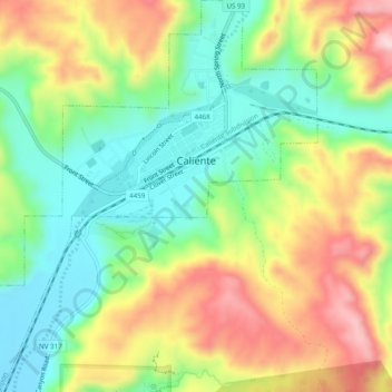
Nombre: Mapa topográfico Caliente, altitud, relieve.
Lugar: Caliente, Lincoln County, Nevada, 09008, United States (37.58973 -114.54477 37.62848 -114.49910)
Altitud media: 1.439 m
Altitud mínima: 1.314 m
Altitud máxima: 1.614 m
Haz una donación
Otros mapas topográficos
Haga clic en un mapa para ver su topografía, su altitud y su relieve.
Haz una donación
Hiko
United States > Nevada > Lincoln County
The Hiko and Crystal Springs provide a large supply of water for the Hiko farms and ranches. The Hiko farming community is located in the north end of the Pahranagat Valley and lies at an elevation of 3,869 feet (1,179 m), with a ZIP code of 89017.
Altitud media: 1.233 m
Haz una donación