
Haz una donación
Mapa topográfico Homer
Haga clic en el mapa para ver la altitud.
Haz una donación
Homer
Some birds seen during the spring migration and the festival include horned puffins, sandhill cranes, and arctic terns. Arctic Terns are famous for flying the longest distance of any migrating bird. Many of the birds seen during the festival can be identified with the help of published guides that categorize distinguishable features such as, topography, silhouette, size, and color. The festival also includes the Shorebirds Sing: Bird Call Contest, where contestants compete to mimic the calls of various bird species.
Haz una donación
Acerca de este mapa
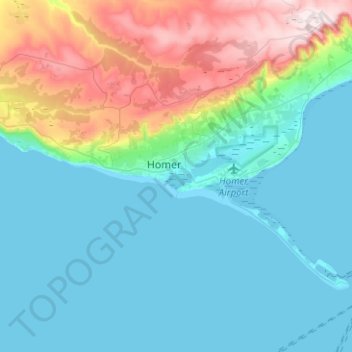
Nombre: Mapa topográfico Homer, altitud, relieve.
Lugar: Homer, Kenai Peninsula Borough, Alaska, United States (59.59903 -151.65504 59.68116 -151.40725)
Altitud media: 105 m
Altitud mínima: 0 m
Altitud máxima: 449 m
Haz una donación
Otros mapas topográficos
Haga clic en un mapa para ver su topografía, su altitud y su relieve.
Augustine Volcano
United States > Alaska > Kenai Peninsula Borough
The nearly circular uninhabited island formed by Augustine Volcano is 12 km (7.5 mi) wide east–west, 10 km (6.2 mi) north-south; a nearly symmetrical central summit peaks at altitude 4,134 feet (1,260 m).
Altitud media: 658 m
Haz una donación
Mount Iliamna
United States > Alaska > Kenai Peninsula Borough
Holocene eruptive activity from Iliamna is little known, but radiocarbon dating seems to indicate at least a few eruptions, all before the European settlement of Alaska. Prehistoric eruptions have been dated to 5050 and 2050 BCE (VEI-4), 450 BCE and 1650. Historically observed eruptions took place in 1867…
Altitud media: 2.360 m
Haz una donación
Augustine Volcano
United States > Alaska > Kenai Peninsula Borough
The nearly circular uninhabited island formed by Augustine Volcano is 12 km (7.5 mi) wide east–west, 10 km (6.2 mi) north-south; a nearly symmetrical central summit peaks at altitude 4,134 feet (1,260 m).
Altitud media: 658 m
Haz una donación
Haz una donación
Augustine Volcano
United States > Alaska > Kenai Peninsula Borough
The nearly circular uninhabited island formed by Augustine Volcano is 12 km (7.5 mi) wide east–west, 10 km (6.2 mi) north-south; a nearly symmetrical central summit peaks at altitude 4,134 feet (1,260 m).
Altitud media: 658 m
Mount Iliamna
United States > Alaska > Kenai Peninsula Borough
Holocene eruptive activity from Iliamna is little known, but radiocarbon dating seems to indicate at least a few eruptions, all before the European settlement of Alaska. Prehistoric eruptions have been dated to 5050 and 2050 BCE (VEI-4), 450 BCE and 1650. Historically observed eruptions took place in 1867…
Altitud media: 2.360 m
Haz una donación