Mapa topográfico Thornton Reservoir
Haga clic en el mapa para ver la altitud.
Acerca de este mapa
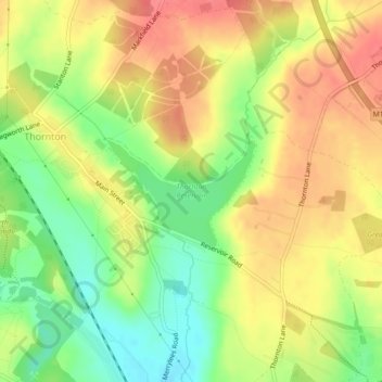
Nombre: Mapa topográfico Thornton Reservoir, altitud, relieve.
Altitud media: 139 m
Altitud mínima: 103 m
Altitud máxima: 168 m

Haga clic en el mapa para ver la altitud.
Nombre: Mapa topográfico Thornton Reservoir, altitud, relieve.
Altitud media: 139 m
Altitud mínima: 103 m
Altitud máxima: 168 m