
Mapa topográfico Dundas
Mapa interactivo
Haga clic en el mapa para ver la altitud.
Acerca de este mapa
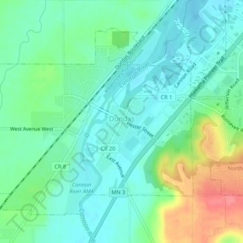
Nombre: Mapa topográfico Dundas, altitud, relieve.
Lugar: Dundas, Rice County, Minnesota, United States (44.41871 -93.22127 44.43951 -93.19062)
Altitud media: 297 m
Altitud mínima: 276 m
Altitud máxima: 347 m
According to the United States Census Bureau, the city has a total area of 1.92 square miles (4.97 km2), all land. The Cannon River passes through the center of town. The latitude of Dundas is 44.429N. The longitude is 93.204W. Dundas' elevation is 932 feet above sea level.
Otros mapas topográficos
Haga clic en un mapa para ver su topografía, su altitud y su relieve.
Heath Creek
United States > Minnesota > Rice County > Northfield
Heath Creek, Northfield, Rice County, Minnesota, 55057, United States
Altitud media: 292 m
Northfield
United States > Minnesota > Rice County
Northfield, Dundas, Rice County, Minnesota, 55057, United States
Altitud media: 300 m
Northfield
United States > Minnesota > Rice County
Northfield, Rice County, Minnesota, 55057, United States
Altitud media: 300 m