
Gracias por apoyar a este sitio ❤️
Haz una donación
Haz una donación
Mapa topográfico High Springs
Haga clic en el mapa para ver la altitud.
Gracias por apoyar a este sitio ❤️
Haz una donación
Haz una donación
Acerca de este mapa
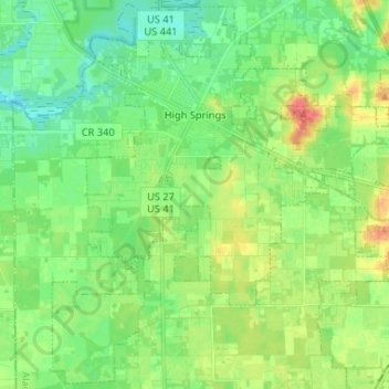
Nombre: Mapa topográfico High Springs, altitud, relieve.
Lugar: High Springs, Alachua County, Florida, 32655, United States (29.74830 -82.64500 29.85839 -82.51422)
Altitud media: 25 m
Altitud mínima: 8 m
Altitud máxima: 55 m
Gracias por apoyar a este sitio ❤️
Haz una donación
Haz una donación
Otros mapas topográficos
Haga clic en un mapa para ver su topografía, su altitud y su relieve.