
Gracias por apoyar a este sitio ❤️
Haz una donación
Haz una donación
Mapa topográfico Oakhurst
Haga clic en el mapa para ver la altitud.
Gracias por apoyar a este sitio ❤️
Haz una donación
Haz una donación
Oakhurst
Oakhurst is located on the Fresno River 3 miles (5 km) south-southwest of Yosemite Forks, at an elevation of 2,274 feet (693 m). Its coordinates are 37°19′41″N 119°38′58″W / 37.32806°N 119.64944°W / 37.32806; -119.64944. It is located at the junction of state highways 41 and 49, at the southern end of California's Gold Country. Nearby communities include Ahwahnee, Coarsegold and Bass Lake.
Gracias por apoyar a este sitio ❤️
Haz una donación
Haz una donación
Acerca de este mapa
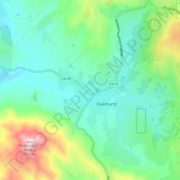
Nombre: Mapa topográfico Oakhurst, altitud, relieve.
Lugar: Oakhurst, Madera County, California, 93644, United States (37.29934 -119.67189 37.36699 -119.61735)
Altitud media: 837 m
Altitud mínima: 644 m
Altitud máxima: 1.385 m
Gracias por apoyar a este sitio ❤️
Haz una donación
Haz una donación
Otros mapas topográficos
Haga clic en un mapa para ver su topografía, su altitud y su relieve.