
Mapa topográfico Town of Middlebury
Mapa interactivo
Haga clic en el mapa para ver la altitud.
Acerca de este mapa
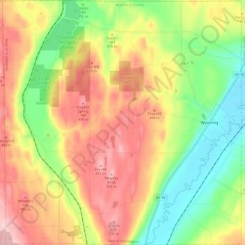
Nombre: Mapa topográfico Town of Middlebury, altitud, relieve.
Lugar: Town of Middlebury, Wyoming County, New York, United States (42.78233 -78.19139 42.87038 -78.07407)
Altitud media: 401 m
Altitud mínima: 285 m
Altitud máxima: 523 m
Otros mapas topográficos
Haga clic en un mapa para ver su topografía, su altitud y su relieve.
Village of Castile
United States > New York > Wyoming County
Village of Castile, Town of Castile, Wyoming County, New York, United States
Altitud media: 420 m
Java Center
United States > New York > Wyoming County
Java Center, Town of Java, Wyoming County, New York, 14082, United States
Altitud media: 471 m
Rock Glen
United States > New York > Wyoming County
Rock Glen, Town of Gainesville, Wyoming County, New York, 14550, United States
Altitud media: 426 m
Town of Covington
United States > New York > Wyoming County
Town of Covington, Wyoming County, New York, United States
Altitud media: 348 m