
Mapa topográfico Dundalk
Haga clic en el mapa para ver la altitud.
Dundalk
The main part of the census town lies at sea level. Dún Dealgan Motte at Castletown is the highest point in the urban area at an elevation of 60 m (200 ft). The municipal district includes the Cooley Mountains, with Slieve Foy the highest of the peaks at an elevation of 589 m (1,932 ft).
Acerca de este mapa
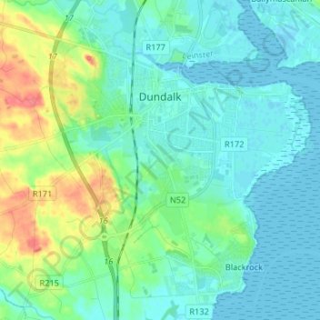
Nombre: Mapa topográfico Dundalk, altitud, relieve.
Lugar: Dundalk, County Louth, Leinster, Ireland (53.95055 -6.44438 54.02793 -6.34154)
Altitud media: 13 m
Altitud mínima: -1 m
Altitud máxima: 59 m
Otros mapas topográficos
Haga clic en un mapa para ver su topografía, su altitud y su relieve.