
Gracias por apoyar a este sitio ❤️
Haz una donación
Haz una donación
Mapa topográfico Redmondville
Haga clic en el mapa para ver la altitud.
Gracias por apoyar a este sitio ❤️
Haz una donación
Haz una donación
Acerca de este mapa
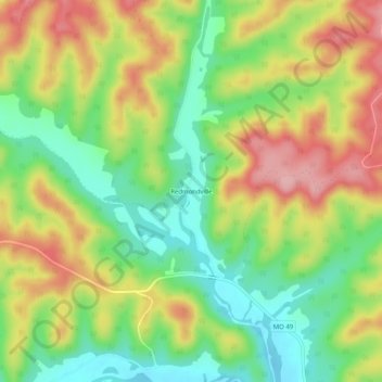
Nombre: Mapa topográfico Redmondville, altitud, relieve.
Lugar: Redmondville, Iron County, Missouri, United States (37.60560 -90.98929 37.64560 -90.94929)
Altitud media: 324 m
Altitud mínima: 257 m
Altitud máxima: 403 m
Gracias por apoyar a este sitio ❤️
Haz una donación
Haz una donación
Otros mapas topográficos
Haga clic en un mapa para ver su topografía, su altitud y su relieve.
Bell Mountain Wilderness
United States > Missouri > Iron County
The United States Congress designated the Bell Mountain Wilderness in 1980. The wilderness area now has a total of 9,027 acres (36.53 km2). Bell Mountain is located within the Potosi-Fredericktown Ranger District of the Mark Twain National Forest, south of Potosi, Missouri in the United States. The wilderness…
Altitud media: 374 m