
Mapa topográfico Rhinelander
Mapa interactivo
Haga clic en el mapa para ver la altitud.
Acerca de este mapa
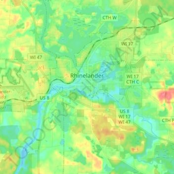
Nombre: Mapa topográfico Rhinelander, altitud, relieve.
Lugar: Rhinelander, Oneida County, Wisconsin, 54501, United States (45.59492 -89.50180 45.66587 -89.36994)
Altitud media: 482 m
Altitud mínima: 462 m
Altitud máxima: 518 m
Rhinelander has a warm-summer humid continental climate (Köppen: Dfb). Because of its location, it is prone to Arctic cold snaps, and without the western Föhn winds its winter average is lower than other places in the US at 45 °N even at high elevations. Summers tend to be cooler with some degree of Lake Superior and Lake Michigan influence. Precipitation is still relatively distributed but not as much as other humid climates in the country.
Otros mapas topográficos
Haga clic en un mapa para ver su topografía, su altitud y su relieve.
McNaughton
United States > Wisconsin > Oneida County > Town of Newbold
McNaughton, Town of Newbold, Oneida County, Wisconsin, 54543, United States
Altitud media: 482 m
Hixon Lake
United States > Wisconsin > Oneida County
Hixon Lake, Town of Pelican, Oneida County, Wisconsin, United States
Altitud media: 484 m
Town of Hazelhurst
United States > Wisconsin > Oneida County
Town of Hazelhurst, Oneida County, Wisconsin, 54531, United States
Altitud media: 486 m
Town of Lake Tomahawk
United States > Wisconsin > Oneida County
Town of Lake Tomahawk, Oneida County, Wisconsin, United States
Altitud media: 490 m
Town of Minoqua
United States > Wisconsin > Oneida County
Town of Minoqua, Oneida County, Wisconsin, United States
Altitud media: 485 m
Town of Woodboro
United States > Wisconsin > Oneida County
Town of Woodboro, Oneida County, Wisconsin, United States
Altitud media: 477 m
Tripoli
United States > Wisconsin > Oneida County
Tripoli, Town of Lynne, Oneida County, Wisconsin, 54564, United States
Altitud media: 470 m
Town of Three Lakes
United States > Wisconsin > Oneida County
Town of Three Lakes, Oneida County, Wisconsin, 54562, United States
Altitud media: 503 m
Sugar Camp Lake
United States > Wisconsin > Oneida County > Town of Sugar Camp > Sugar Camp
Sugar Camp Lake, Sugar Camp, Town of Sugar Camp, Oneida County, Wisconsin, United States
Altitud media: 508 m
Prairie Lake
United States > Wisconsin > Oneida County
Prairie Lake, Town of Nokomis, Oneida County, Wisconsin, United States
Altitud media: 457 m
Stella Lake
United States > Wisconsin > Oneida County
Stella Lake, Town of Stella, Oneida County, Wisconsin, United States
Altitud media: 503 m
Stella
United States > Wisconsin > Oneida County
Stella, Town of Stella, Oneida County, Wisconsin, United States
Altitud media: 491 m
Norway Island
United States > Wisconsin > Oneida County
Norway Island, Town of Minoqua, Oneida County, Wisconsin, United States
Altitud media: 488 m
Monico
United States > Wisconsin > Oneida County > Monico
Monico, Town of Monico, Oneida County, Wisconsin, United States
Altitud media: 494 m
Town of Pine Lake
United States > Wisconsin > Oneida County
Town of Pine Lake, Oneida County, Wisconsin, United States
Altitud media: 485 m
Dam Lake
United States > Wisconsin > Oneida County > Town of Sugar Camp
Dam Lake, Town of Sugar Camp, Oneida County, Wisconsin, United States
Altitud media: 493 m
Pelican Lake
United States > Wisconsin > Oneida County
Pelican Lake, Town of Schoepke, Oneida County, Wisconsin, 54463, United States
Altitud media: 487 m
Yukon Creek
United States > Wisconsin > Oneida County
Yukon Creek, Town of Minoqua, Oneida County, Wisconsin, United States
Altitud media: 481 m
Minocqua
United States > Wisconsin > Oneida County
Minocqua, Town of Minoqua, Oneida County, Wisconsin, United States
Altitud media: 491 m
Clearwater Lake
United States > Wisconsin > Oneida County > Town of Three Lakes
Clearwater Lake, Town of Three Lakes, Oneida County, Wisconsin, United States
Altitud media: 500 m