
Haz una donación
Mapa topográfico Round Valley
Haga clic en el mapa para ver la altitud.
Haz una donación
Acerca de este mapa
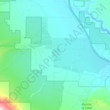
Nombre: Mapa topográfico Round Valley, altitud, relieve.
Lugar: Round Valley, Inyo County, California, United States (37.37720 -118.62148 37.43916 -118.52742)
Altitud media: 1.491 m
Altitud mínima: 1.333 m
Altitud máxima: 2.434 m
Haz una donación
Otros mapas topográficos
Haga clic en un mapa para ver su topografía, su altitud y su relieve.
Big Pine
United States > California > Inyo County > Big Pine
Big Pine (formerly, Bigpine) is a census-designated place (CDP) in Inyo County, California, United States. Big Pine is located approximately 15 miles (24 km) south-southeast of Bishop, at an elevation of 3,989 feet (1,216 m). The population was 1,756 at the 2010 census, up from 1,350 at the 2000 census. The…
Altitud media: 1.228 m
Lone Pine
United States > California > Inyo County
Lone Pine is a census-designated place (CDP) in Inyo County, California, United States. Lone Pine is located 16 mi (26 km) south-southeast of Independence, at an elevation of 3,727 ft (1,136 m). The population was 2,035 at the 2010 census, up from 1,655 at the 2000 census. The town is located in the Owens…
Altitud media: 1.298 m
Furnace Creek
United States > California > Inyo County > Indian Village
Furnace Creek (formerly Greenland Ranch) is a census-designated place (CDP) in Inyo County, California, United States. The population was 136 at the 2020 census, up from 24 at the 2010 census. The elevation of the village is 190 feet (58 m) below sea level. The visitor center, museum, and headquarters of Death…
Altitud media: 166 m
Haz una donación
Bishop
United States > California > Inyo County
Bishop (formerly Bishop Creek) is a city in California, United States. It is the largest populated place and only incorporated city in Inyo County. Bishop is located near the northern end of the Owens Valley, at an elevation of 4,150 feet (1,260 m). The city was named after Bishop Creek, flowing out of the…
Altitud media: 1.265 m
Haz una donación
Mount Williamson
United States > California > Inyo County
Mount Williamson, at an elevation of 14,379 feet (4,383 m), is the second-highest mountain in both the Sierra Nevada range and the state of California, and the sixth-highest peak in the contiguous United States.
Altitud media: 3.821 m
Haz una donación
Palisade Glacier
United States > California > Inyo County
The Palisade Glacier is a glacier located on the northeast side of the Palisades within the John Muir Wilderness in the central Sierra Nevada of California. The glacier descends from the flanks of four fourteeners, or mountain peaks over 14,000 ft (4,300 m) in elevation, including North Palisade (14,242 ft…
Altitud media: 3.839 m
Haz una donación
Independence
United States > California > Inyo County > Independence
Independence is an unincorporated census-designated place in and the county seat of Inyo County, California. Independence is located 41 miles (66 km) south-southeast of Bishop, at an elevation of 3930 feet (1198 m). The population of this census-designated place was 593 at the 2020 census, down from 669 at the…
Altitud media: 1.199 m
Haz una donación
Haz una donación
Haz una donación
Haz una donación
Haz una donación
Haz una donación
Haz una donación
Independence
United States > California > Inyo County
Independence is a census-designated place in Inyo County, California. Independence is located 41 miles (66 km) south-southeast of Bishop, at an elevation of 3930 feet (1198 m). It is the county seat of Inyo County, California. The population of this census-designated place was 669 at the 2010 census, up from…
Altitud media: 1.210 m
Bishop
United States > California > Inyo County
Bishop (formerly Bishop Creek) is a city in California, United States. It is the largest populated place and only incorporated city in Inyo County. Bishop is located near the northern end of the Owens Valley, at an elevation of 4,150 feet (1,260 m). The city was named after Bishop Creek, flowing out of the…
Altitud media: 1.265 m
Haz una donación