
Mapa topográfico Kilbirnie
Mapa interactivo
Haga clic en el mapa para ver la altitud.
Acerca de este mapa
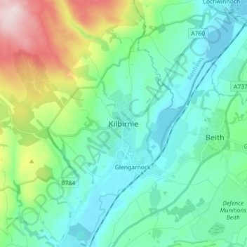
Nombre: Mapa topográfico Kilbirnie, altitud, relieve.
Lugar: Kilbirnie, North Ayrshire, Scotland, KA25 7BY, United Kingdom (55.71519 -4.72551 55.79519 -4.64551)
Altitud media: 121 m
Altitud mínima: 23 m
Altitud máxima: 443 m
Otros mapas topográficos
Haga clic en un mapa para ver su topografía, su altitud y su relieve.
Grangehill
United Kingdom > Scotland > North Ayrshire > Beith
Grangehill, Beith, North Ayrshire, Scotland, KA15 2JJ, United Kingdom
Altitud media: 96 m
Ballochmartin
United Kingdom > Scotland > North Ayrshire > Millport > Ballochmartin
Ballochmartin, Millport, North Ayrshire, Scotland, KA28 0HQ, United Kingdom
Altitud media: 22 m
Kilwinning
United Kingdom > Scotland > North Ayrshire
Kilwinning, North Ayrshire, Scotland, KA13 6AD, United Kingdom
Altitud media: 36 m
Ardrossan
United Kingdom > Scotland > North Ayrshire
Ardrossan, North Ayrshire, Scotland, KA22 8BS, United Kingdom
Altitud media: 21 m
Irvine
United Kingdom > Scotland > North Ayrshire
Irvine, North Ayrshire, Scotland, KA12 0AX, United Kingdom
Altitud media: 13 m