
Gracias por apoyar a este sitio ❤️
Haz una donación
Haz una donación
Mapa topográfico Lousã
Haga clic en el mapa para ver la altitud.
Gracias por apoyar a este sitio ❤️
Haz una donación
Haz una donación
Lousã
Lousã sits at around 200 m (660 ft) high, and it currently has an active station at its aerodrome, but because this station is relatively new, data from the older, now inactive station in the mountains nearby, at a higher altitude, is also represented in the climate chart below.
Gracias por apoyar a este sitio ❤️
Haz una donación
Haz una donación
Acerca de este mapa
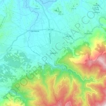
Nombre: Mapa topográfico Lousã, altitud, relieve.
Lugar: Lousã, Lousã e Vilarinho, Lousã, Coimbra, 3200-200, Portugal (40.07115 -8.28616 40.15115 -8.20616)
Altitud media: 335 m
Altitud mínima: 75 m
Altitud máxima: 1.048 m
Gracias por apoyar a este sitio ❤️
Haz una donación
Haz una donación