
Mapa topográfico Alto
Haga clic en el mapa para ver la altitud.
Alto
The town of Alto was laid out in 1849 and named for the Spanish word meaning "high" on account of the site's elevation on a drainage divide between the Neches and Angelina Rivers.
Acerca de este mapa
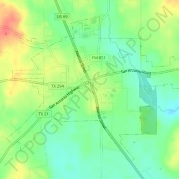
Nombre: Mapa topográfico Alto, altitud, relieve.
Lugar: Alto, Cherokee County, Texas, United States (31.63611 -95.09026 31.66238 -95.05245)
Altitud media: 130 m
Altitud mínima: 106 m
Altitud máxima: 163 m
Otros mapas topográficos
Haga clic en un mapa para ver su topografía, su altitud y su relieve.
Jacksonville
United States > Texas > Cherokee County > Jacksonville > Jacksonville
Altitud media: 154 m