
Gracias por apoyar a este sitio ❤️
Haz una donación
Haz una donación
Mapa topográfico Roach
Haga clic en el mapa para ver la altitud.
Gracias por apoyar a este sitio ❤️
Haz una donación
Haz una donación
Acerca de este mapa
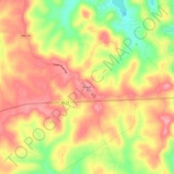
Nombre: Mapa topográfico Roach, altitud, relieve.
Lugar: Roach, Camden County, Missouri, United States (37.97392 -92.85630 38.01392 -92.81630)
Altitud media: 263 m
Altitud mínima: 191 m
Altitud máxima: 310 m
Gracias por apoyar a este sitio ❤️
Haz una donación
Haz una donación
Otros mapas topográficos
Haga clic en un mapa para ver su topografía, su altitud y su relieve.
Gracias por apoyar a este sitio ❤️
Haz una donación
Haz una donación
Gracias por apoyar a este sitio ❤️
Haz una donación
Haz una donación
Linn Creek
United States > Missouri > Camden County
In 1929, it was announced that the Bagnell Dam would be constructed and the town would be flooded, causing controversy among the city's citizens. Almost all of the buildings were demolished, and the city was moved to a higher elevation, losing its designation as the county seat. The location where Linn Creek…
Altitud media: 250 m