
Gracias por apoyar a este sitio ❤️
Haz una donación
Haz una donación
Mapa topográfico Alpine
Haga clic en el mapa para ver la altitud.
Gracias por apoyar a este sitio ❤️
Haz una donación
Haz una donación
Alpine
Alpine sits on both sides of Interstate 8 at the eastern extent of the California coastal region and the western extent of the Peninsular Ranges, about 30 miles (48 km) east of downtown San Diego, at an elevation of about 2,000 feet (610 m).
Gracias por apoyar a este sitio ❤️
Haz una donación
Haz una donación
Acerca de este mapa
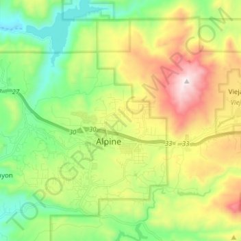
Nombre: Mapa topográfico Alpine, altitud, relieve.
Lugar: Alpine, San Diego County, California, 91901, United States (32.79892 -116.81959 32.88910 -116.69466)
Altitud media: 581 m
Altitud mínima: 170 m
Altitud máxima: 1.272 m
Gracias por apoyar a este sitio ❤️
Haz una donación
Haz una donación