
Gracias por apoyar a este sitio ❤️
Haz una donación
Haz una donación
Mapa topográfico Aubeterre-sur-Dronne
Haga clic en el mapa para ver la altitud.
Gracias por apoyar a este sitio ❤️
Haz una donación
Haz una donación
Aubeterre-sur-Dronne
The highest point of the commune is at an altitude of 111m and is located on the plateau near the northern boundary. The lowest point is 38m located on the southern boundary next to the Dronne. The commune is spread between the valley of the Dronne and the top of the hill.
Gracias por apoyar a este sitio ❤️
Haz una donación
Haz una donación
Acerca de este mapa
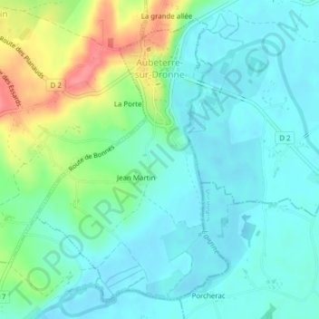
Nombre: Mapa topográfico Aubeterre-sur-Dronne, altitud, relieve.
Altitud media: 60 m
Altitud mínima: 38 m
Altitud máxima: 119 m
Gracias por apoyar a este sitio ❤️
Haz una donación
Haz una donación
Otros mapas topográficos
Haga clic en un mapa para ver su topografía, su altitud y su relieve.
Gracias por apoyar a este sitio ❤️
Haz una donación
Haz una donación
Gracias por apoyar a este sitio ❤️
Haz una donación
Haz una donación
Gracias por apoyar a este sitio ❤️
Haz una donación
Haz una donación
Gracias por apoyar a este sitio ❤️
Haz una donación
Haz una donación
Gracias por apoyar a este sitio ❤️
Haz una donación
Haz una donación