
Haz una donación
Mapa topográfico Tysons
Haga clic en el mapa para ver la altitud.
Haz una donación
Tysons
Tysons is located at 38°55′7″N 77°13′47″W / 38.91861°N 77.22972°W / 38.91861; -77.22972 (38.918485, −77.229833) at an elevation of 486 feet (148 m). Located in Northern Virginia at the intersection of Virginia State Route 123 and State Route 7, Tysons is 11 miles (18 km) west of downtown Washington, D.C. and 6 miles (9.7 km) northeast of Fairfax, the county seat.
Haz una donación
Acerca de este mapa
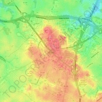
Nombre: Mapa topográfico Tysons, altitud, relieve.
Lugar: Tysons, Fairfax County, Virginia, 22103, United States (38.90340 -77.25444 38.93493 -77.19624)
Altitud media: 122 m
Altitud mínima: 75 m
Altitud máxima: 164 m
Haz una donación
Otros mapas topográficos
Haga clic en un mapa para ver su topografía, su altitud y su relieve.
Haz una donación
George Washington's Mount Vernon
United States > Virginia > Fairfax County > Mount Vernon
Visitors to Mount Vernon now see Washington's study, a room to which in the 18th century only a privileged few were granted entry. This simply furnished room has a combined bathroom, dressing room and office; the room was so private that few contemporary descriptions exist. Its walls are lined with naturally…
Altitud media: 14 m
Izaak Walton League of America - Arlington-Fairfax Chapter
United States > Virginia > Fairfax County > Centreville
Altitud media: 72 m
Haz una donación
Haz una donación
Haz una donación
Mount Vernon Community Park
United States > Virginia > Fairfax County > Fort Hunt > Snowden
Altitud media: 14 m
Haz una donación
Shirley Gate Park
United States > Virginia > Fairfax County > George Mason > Shirley Gate Park
Altitud media: 128 m
Haz una donación