
Mapa topográfico Island Park
Mapa interactivo
Haga clic en el mapa para ver la altitud.
Acerca de este mapa
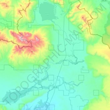
Nombre: Mapa topográfico Island Park, altitud, relieve.
Lugar: Island Park, Fremont County, Idaho, United States (44.35841 -111.43899 44.67472 -111.31598)
Altitud media: 2.113 m
Altitud mínima: 1.869 m
Altitud máxima: 3.088 m
Island Park is located at 44°29′59″N 111°20′19″W / 44.49972°N 111.33861°W / 44.49972; -111.33861 (44.4996, −111.3387), at an elevation of 6,293 feet (1,918 m) above sea level, making it the highest city in Idaho.
Otros mapas topográficos
Haga clic en un mapa para ver su topografía, su altitud y su relieve.
Box Canyon
United States > Idaho > Fremont County
Box Canyon, Fremont County, Idaho, United States
Altitud media: 1.891 m
Sawtell Peak
United States > Idaho > Fremont County
Sawtell Peak, Fremont County, Idaho, United States
Altitud media: 2.661 m