
Mapa topográfico Pittsburgh
Mapa interactivo
Haga clic en el mapa para ver la altitud.
Acerca de este mapa
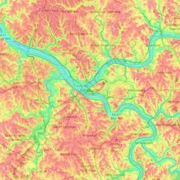
Nombre: Mapa topográfico Pittsburgh, altitud, relieve.
Altitud media: 315 m
Altitud mínima: 209 m
Altitud máxima: 424 m
The warmest month of the year in Pittsburgh is July, with a 24-hour average of 72.6 °F (22.6 °C). Conditions are often humid, and combined with highs reaching 90 °F (32 °C) on an average 9.5 days a year, a considerable heat index arises. The coolest month is January, when the 24-hour average is 28.4 °F (−2.0 °C), and lows of 0 °F (−18 °C) or below can be expected on an average 2.6 nights per year. Officially, record temperatures range from −22 °F (−30 °C), on January 19, 1994 to 103 °F (39 °C), which occurred three times, most recently on July 16, 1988; the record cold daily maximum is −3 °F (−19 °C), which occurred three times, most recently the day of the all-time record low, while, conversely, the record warm daily minimum is 82 °F (28 °C) on July 1, 1901. Due to elevation and location on the windward side of the Appalachian Mountains, 100 °F (38 °C)+ readings are very rare, and were last seen on July 15, 1995.
Otros mapas topográficos
Haga clic en un mapa para ver su topografía, su altitud y su relieve.
Middle Hill
United States of America > Pennsylvania > Pittsburgh
Middle Hill, Pittsburgh, Allegheny County, Pennsylvania, 15219, United States of America
Altitud media: 283 m