
Mapa topográfico Orofino
Mapa interactivo
Haga clic en el mapa para ver la altitud.
Acerca de este mapa
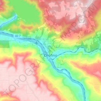
Nombre: Mapa topográfico Orofino, altitud, relieve.
Lugar: Orofino, Clearwater County, Idaho, 83544, United States (46.47097 -116.32122 46.49939 -116.19855)
Altitud media: 633 m
Altitud mínima: 293 m
Altitud máxima: 964 m
Due to the area’s relatively low elevation, the climate is ranked as among the hottest in the summer and the mildest in the winter throughout the entire state. The moderate winters are also influenced by the city’s northwestern location, which places it closer to the Pacific Ocean than many other parts of Idaho. Idaho’s all-time highest temperature of 118 °F or 47.8 °C was recorded at Orofino on July 28, 1934.
Otros mapas topográficos
Haga clic en un mapa para ver su topografía, su altitud y su relieve.
Weippe
United States > Idaho > Clearwater County
Weippe, Clearwater County, Idaho, 83553, United States
Altitud media: 926 m
Ahsahka
United States > Idaho > Clearwater County
Ahsahka, Clearwater County, Idaho, 83520, United States
Altitud media: 422 m
Elk River
United States > Idaho > Clearwater County
Elk River, Clearwater County, Idaho, 83827, United States
Altitud media: 907 m
Pierce
United States > Idaho > Clearwater County
Pierce, Clearwater County, Idaho, 83546, United States
Altitud media: 1.004 m
Orofino
United States > Idaho > Clearwater County > Orofino > Orofino
Orofino, Clearwater County, Idaho, 83544, United States
Altitud media: 627 m