
Mapa topográfico Cabassude
Mapa interactivo
Haga clic en el mapa para ver la altitud.
Acerca de este mapa
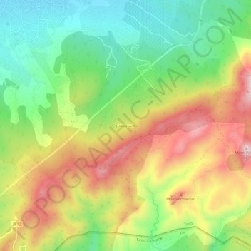
Nombre: Mapa topográfico Cabassude, altitud, relieve.
Altitud media: 450 m
Altitud mínima: 260 m
Altitud máxima: 689 m
Otros mapas topográficos
Haga clic en un mapa para ver su topografía, su altitud y su relieve.
Mont Olympe
France > Provence-Alpes-Côte d'Azur > Bouches-du-Rhône > Trets
Mont Olympe, Trets, Aix-en-Provence, Bouches-du-Rhône, Provence-Alpes-Côte d'Azur, France métropolitaine, 13530, France
Altitud media: 553 m
Bergerie du Perdu
France > Provence-Alpes-Côte d'Azur > Bouches-du-Rhône > Trets
Bergerie du Perdu, Trets, Aix-en-Provence, Bouches-du-Rhône, Provence-Alpes-Côte d'Azur, France métropolitaine, 13530, France
Altitud media: 519 m
Pas de la Couelle
France > Provence-Alpes-Côte d'Azur > Bouches-du-Rhône > Trets
Pas de la Couelle, Trets, Aix-en-Provence, Bouches-du-Rhône, Provence-Alpes-Côte d'Azur, France métropolitaine, 13530, France
Altitud media: 473 m
Kirbon
France > Provence-Alpes-Côte d'Azur > Bouches-du-Rhône > Trets
Kirbon, Trets, Aix-en-Provence, Bouches-du-Rhône, Provence-Alpes-Côte d'Azur, France métropolitaine, 13530, France
Altitud media: 442 m