
Gracias por apoyar a este sitio ❤️
Haz una donación
Haz una donación
Mapa topográfico Cordelia
Haga clic en el mapa para ver la altitud.
Gracias por apoyar a este sitio ❤️
Haz una donación
Haz una donación
Acerca de este mapa
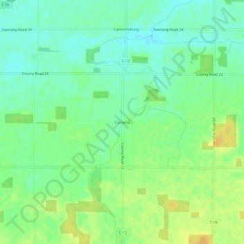
Nombre: Mapa topográfico Cordelia, altitud, relieve.
Lugar: Cordelia, Hancock County, Ohio, United States (40.87950 -83.80577 40.91950 -83.76577)
Altitud media: 261 m
Altitud mínima: 249 m
Altitud máxima: 275 m
Gracias por apoyar a este sitio ❤️
Haz una donación
Haz una donación
Otros mapas topográficos
Haga clic en un mapa para ver su topografía, su altitud y su relieve.
Findlay
United States > Ohio > Hancock County
Findlay is situated on relatively flat terrain within the northwest region of the state, characterized by gently rolling hills and fertile plains. The city lies at an elevation of approximately 800 feet (244 meters) above sea level, with the Blanchard River meandering through the area, contributing to the…
Altitud media: 243 m