
Haz una donación
Mapa topográfico Oldsmar
Haga clic en el mapa para ver la altitud.
Haz una donación
Oldsmar
Oldsmar features a gently rolling terrain characterized by a mix of low-lying wetlands and elevated areas. The city sits at an average elevation of about 20 feet above sea level, providing it with a unique vantage point over the surrounding landscapes. Its proximity to Tampa Bay influences the topography, with lush vegetation and native coastal ecosystems thriving in the area. The terrain is interspersed with small lakes and ponds, contributing to the region’s biodiversity. Additionally, the Upper Tampa Bay Trail offers a scenic pathway that traverses the varied landscapes, allowing residents and visitors to appreciate the natural beauty of Oldsmar's topography.
Haz una donación
Acerca de este mapa
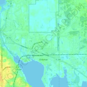
Nombre: Mapa topográfico Oldsmar, altitud, relieve.
Lugar: Oldsmar, Pinellas County, Florida, United States (28.00847 -82.71044 28.08956 -82.64850)
Altitud media: 6 m
Altitud mínima: -3 m
Altitud máxima: 23 m
Haz una donación
Otros mapas topográficos
Haga clic en un mapa para ver su topografía, su altitud y su relieve.
Palm Harbor
United States > Florida > Pinellas County
Palm Harbor is characterized by its unique topography, which features a relatively rare hilly landscape for the region. Unlike much of the surrounding areas in Pinellas County, which are predominantly flat, Palm Harbor includes elevations that can reach up to about 75 feet above sea level. This elevation gives…
Altitud media: 9 m
Haz una donación
Haz una donación
Haz una donación
Fort De Soto County Park
United States > Florida > Pinellas County > Saint Petersburg
Altitud media: 0 m
Saint Petersburg County Park
United States > Florida > Pinellas County > Saint Pete Beach
Altitud media: 1 m
Haz una donación
Haz una donación
Haz una donación
Haz una donación
Haz una donación
Lealman
United States > Florida > Pinellas County
Lealman is located at 27°49′10″N 82°41′4″W / 27.81944°N 82.68444°W / 27.81944; -82.68444 (27.8197, -82.6846). The community is bordered by the city of Pinellas Park to the north, St. Petersburg to the east and south, and by the town of West Lealman to the west. The elevation is 49 feet (15…
Altitud media: 13 m
Haz una donación
Boyd Hill Nature Preserve
United States > Florida > Pinellas County > Saint Petersburg > Lakewood Estates
Altitud media: 7 m
Haz una donación
Haz una donación
Haz una donación
Splash Harbour Water Park
United States > Florida > Pinellas County > Indian Rocks Beach
Altitud media: 4 m
Boyd Hill Nature Preserve
United States > Florida > Pinellas County > Saint Petersburg > Lakewood Estates
Altitud media: 7 m
Haz una donación
Haz una donación
Haz una donación
Haz una donación
Haz una donación
Haz una donación
Haz una donación